UpGo!
iPhone / Sports
Climbing safely with abundant functions such as browsing the map offline, notifying the current position by voice, searching for a destination with AR View, importing an external GPX file, and safety confirmation.
UpGo!'s recorded data is stored only on your device and can be used safely without advertisements. You can save up to 5 times in the free version. If you like it, you can save it as many times as you like (only billing 100 yen), and you can use the tracking function using iCloud. With the tracking function, the movement data of the person who is acting on another iPhone or iPad is displayed on the UpGo! map in near real time. This is an epoch-making function for confirming safety.
<Major features>
◎ Use offline maps
If you browse the map in advance, you can see the map even in places where there is no internet connection. There is no charge no matter how you look.
◎ Map selection
You can select from four types of maps: Japan maps(Geospatial Information Authority of Japan), Apple Standard maps, Aerial photographs, Aerial photographs + Standard maps.
◎ Voice notification
You can hear the time, altitude, and travel distance by voice at set time interval.
◎ AR View using AR technology
AR View that displays the destination label on the camera image has been realized. The position of the goal can be confirmed with an image, and the altitude difference from the destination (in Japan) and the straight line distance are displayed.
◎ Map and photo album
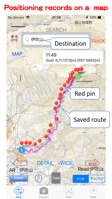
You can look back at the Positioning Record and Photo Record with the map and look back on the activities later.
◎ Safety confirmation with tracking function
Using iCloud signed in with the same Apple ID, you can display movement data on the UpGo! map on a different device from the person who is walking (being active). (Requires mobile signal)
◎ Activities that spread through information exchange.
You can send and receive UpGo! data to other UpGo!. In addition, the photo screen with the positioning results and action notes can be saved on the device. You can share real lively information with people who do not have UpGo!.
*GPX files provided by general mountain climbing or hiking sites can be read and walking courses can be displayed.
◎ Used for many purposes
In addition to climbing and hiking, it can also be used for cycling and walking.
*The first time you use UpGo!, Map of Tokyo will be displayed. Next, when you start positioning by tapping the 'START' button, you will be asked for permission to use location information. Please allow it to be used.
<Recommended models and OS>
The recommended model is iPhone5S or later, and the OS is iOS9 or later.
Important points
◎UpGo! is not suitable for mountaineering outside of Japan. Use in the city is recommended.
◎ UpGp! developer cannot be held responsible for accidents in UpGo! Activities. Please use it safely at your own risk.
◎ It is recommended that you carry a mobile battery, etc., in preparation for battery consumption.
◎ There are rules regarding the use of maps of the Geospatial Information Authority of Japan. Please note that you may need to apply for use when the map background image is uploaded to the Internet or distributed in print.
◎ The mechanism to obtain the elevation data by dropping the purple pin uses the elevation API of the Geospatial Information Authority of Japan. ’Src = 5m (レーザ)’ displayed in the balloon means 5mDEM obtained by aerial laser surveying. ’Src = 5m (写真測量)’ means 5mDEM obtained from photographic data, and ’Src = 10m’ means 10mDEM obtained from contour lines. Geospatial Information Authority's elevation API is open to the public and may be discontinued without prior notice.
Quoi de neuf dans la dernière version ?
Fixed an error on the latest iOS when searching on the Map screen..