Fires: Incendies et Atlas
iOS Universel / Actualités
Restez informé et en sécurité avec l'application de suivi d'incendies la plus fiable. Regardez les aéronefs de lutte en temps réel avec sphères 3D et traces de vol. Utilisée par pompiers et millions mondialement.
SUIVI D'INCENDIES EN TEMPS RÉEL
Suivi d'aéronefs en direct avec missions codées par couleur. Globe 3D avancé propulsé par technologie WhirlyGlobe.
- Emplacements d'incendies en direct, périmètres, confinement
- Suivi d'aéronefs avec traces (bleu=hélicoptère eau, orange=avions-citernes, vert=commande)
- Notifications push intelligentes pour incidents proximité
- Alertes météo sur cartes d'urgence
- Zones d'évacuation en temps réel
- Pannes électriques (Californie)
- Cartes hors ligne sans service cellulaire
SOURCES OFFICIELLES POMPIERS
- InciWeb - Système National Information Incidents
- CAL FIRE - Département Foresterie Californie
- NIFC - Centre National Interagences Incendies
- NASA FIRMS - Détection satellitaire
- NOAA - Conditions météo
- Service Météorologique - Avertissements Drapeau Rouge
- International - NSW RFS, CFA, QFES, CFS (Australie)
INTELLIGENCE SÉCURITÉ
- Points chauds thermiques globaux
- Conditions vent temps réel et météo feu
- Alertes météo critiques cartes urgence
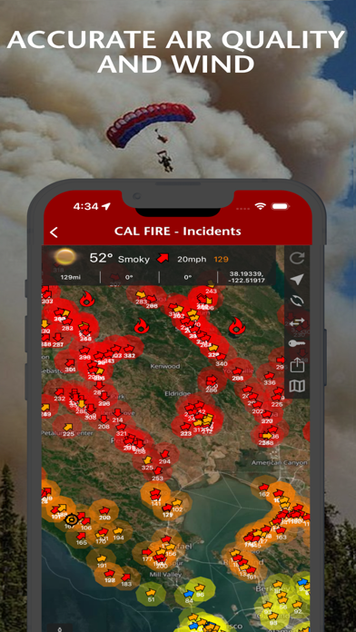
- Surveillance qualité air fumée
- Globe 3D interactif rendu atmosphérique
- 80+ cartes hors ligne Forêts Nationales BLM
- Photographie haute résolution
ATLAS FIRES - CARTOGRAPHIE PROFESSIONNELLE
Transformez appareil en outil professionnel lutte incendies avec cartographie hors ligne complète. Couverture Californie, Oregon, Washington, Alaska, Arizona, Nevada.
POURQUOI CHOISIR FIRES?
- Plus Complet - Couverture mondiale détail local
- Alertes Rapides - Notifications push sauvent vies
- Plus Fiable - Capacité hors ligne réseaux échouent
- Grade Professionnel - Sources données pompiers
Parfait propriétaires zones incendies, plein air, urgences, pompiers professionnels.
ABONNEMENTS
Les abonnements se renouvellent automatiquement sauf si désactivé 24 heures avant fin période. Compte iTunes facturé 24 heures avant fin période.
Fires Pro Elite ($29.99/an)
Accès annuel Atlas Fires complet, accès illimité Cartes Base, références BLM et USFS.
- Accès Conditions Météo Incidents
- Accès Conditions Météo Proximité
- Conditions Météo Globales Illimitées Points Repère
Fires Pro ($14.99/an)
Accès annuel Cartes Base avec 4 cartes référence BLM USFS. Sélections 3 mois chacune.
- Accès Conditions Météo Incidents
- Essai gratuit 7 jours
GÉRER ABONNEMENT:
- DÉSACTIVER auto-renouvellement app Réglages: http://support.apple.com/kb/ht4098
- Abonnements renouvellent automatiquement sauf si désactivé 24h avant fin période
- Compte iTunes facturé confirmation achat
- Politique Confidentialité: http://www.livewaremedia.com/p/privacy-policy.html
- Conditions utilisation: http://www.livewaremedia.com/p/terms-and-conditions.html
Quoi de neuf dans la dernière version ?
Merci de faire de Fires votre compagnon de confiance pour la sécurité incendie!
Liste et Détails des Avions CalFire
Restez informé des opérations aériennes de lutte contre les incendies avec notre nouvelle liste d'avions et cartes d'information détaillées. Touchez n'importe quel avion CalFire sur le globe pour voir les données de mission en temps réel, y compris le type d'avion, la vitesse actuelle, le cap et l'altitude. Accédez à la liste complète des avions actifs d'un seul toucher pour trouver rapidement les informations dont vous avez besoin pendant les opérations critiques.
Alertes de Localisation sur Liste de Surveillance
Protégez ce qui compte le plus avec la surveillance de localisation personnalisée. Ajoutez jusqu'à 3 emplacements n'importe où dans le monde et recevez des notifications push lorsque des incendies de forêt sont détectés dans le rayon que vous avez choisi. Définissez votre distance d'alerte de 40 à 800 kilomètres pour chaque emplacement. Parfait pour surveiller votre maison, les propriétés familiales ou vos destinations de plein air préférées même lorsque vous êtes absent.
Cartographie des Pannes de Courant
Les pannes de courant liées aux incendies de forêt sont maintenant visibles sur le globe interactif. Touchez n'importe quel polygone de panne pour voir le nombre de clients affectés, le fournisseur de services publics et l'heure de rétablissement estimée. Restez informé des impacts sur l'infrastructure pendant les urgences d'incendie.
Détails des Zones d'Évacuation
Accédez rapidement aux informations d'évacuation critiques en touchant n'importe quelle zone d'évacuation sur la carte. Consultez les ordres et avertissements d'évacuation officiels avec des liens directs vers les cartes d'urgence Genasys montrant les limites de zone les plus récentes et les instructions de sécurité pour votre région.
Détails des Veilles et Avertissements Météorologiques
Le système d'alerte météorologique amélioré comprend maintenant des informations détaillées pour toutes les veilles et avertissements actifs. Touchez n'importe quelle alerte pour voir les descriptions complètes et les limites géographiques afin de mieux comprendre les conditions météorologiques qui pourraient affecter le comportement des incendies de forêt
.
Performance et Fiabilité
Précision améliorée du suivi des avions avec des mises à jour de position en temps réel. Performance de rendu de carte améliorée pour une interaction plus fluide avec le globe. Imagerie météorologique mise à jour pour une meilleure visibilité et une apparence moderne dans toutes les conditions.
Nous nous engageons à assurer votre sécurité et celle de vos proches. Si Fires vous a aidé à rester informé, veuillez envisager de laisser un avis.
Restez en sécurité,
L'équipe Fires