• KultureGeek
  • Comparateur de prix
       
iPhoneAddict
 iAddictv5Notre Application iPhone/iPad
  • Accueil Apps
  • Actualité Apple
  • Keynote Apple
  • Firmwares & iTunes
  • Contactez-nous
Accueil » Liste des Apps » Apps iPad » Economie et entreprise » Site Scan for ArcGIS - LE
4.3.1 iOS €Gratuit ESRI 0 0 Site Scan for ArcGIS Limited Edition (LE) is a simplified version of the Site Scan for ArcGIS Flight Planning App, built for ArcGIS Drone2Map users, that allows you to easily capture rich imagery using advanced drone flights. Use your favorite maps...
Site Scan for ArcGIS - LE

Site Scan for ArcGIS - LE

iPad / Economie et entreprise

Gratuit
Obtenir sur l'App Store

Site Scan for ArcGIS Limited Edition (LE) is a simplified version of the Site Scan for ArcGIS Flight Planning App, built for ArcGIS Drone2Map users, that allows you to easily capture rich imagery using advanced drone flights.

Use your favorite maps and layers from ArcGIS Online to plan accurate missions in Site Scan for ArcGIS - LE. Process your images in ArcGIS Drone2Map or an alternative stitching software to create 2D and 3D data products. Experienced pilots can use Terrain Follow, which enhances imagery quality by adjusting the drone's height to follow the terrain.

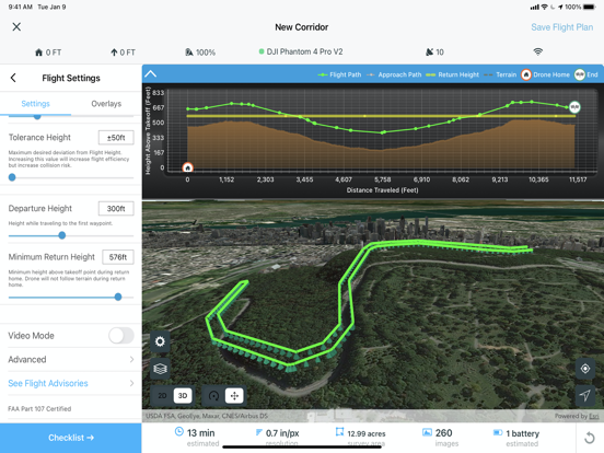
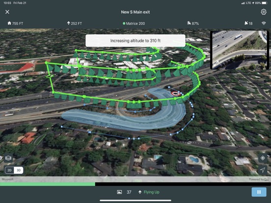
Choose from a variety of flight modes tailored to the type of site being scanned, and the app will automatically define the optimal flight path and allow you to preview it in 2D or 3D.

The app automatically conducts aircraft checks and executes the flight. Long flights are automatically split, allowing you to change your drone’s battery and resume where you left off.


Compatibility:
- Requires compatible drone: DJI P4 Advanced, DJI P4P, DJI P4P V2, DJI P4 RTK, Mavic Pro, Mavic 2 Pro, M200 series, M200 series V2, Inspire 2, DJI M300RTK.
- Requires ArcGIS Drone2Map or other image processing software to create 2D and 3D data products
- ArcGIS Online subscription required

En voir plus...

Quoi de neuf dans la dernière version ?

- DJI M300RTK support with P1 camera
- Flight speed setting
- Define mission area from polygon
- iOS 15 Support
- Retire support for H520-G drone and Zenmuse Z30 camera
- Additional bug fixes

  • Screenshot #4 pour Site Scan for ArcGIS - LE
  • Screenshot #5 pour Site Scan for ArcGIS - LE
  • Screenshot #6 pour Site Scan for ArcGIS - LE

D'autres applications du développeur

Esri Events
Esri Events
/ iOS Universel
ArcGIS Business Analyst
/ iOS Universel
Esri Campus Tour
Esri Campus Tour
/ iOS Universel
Palm Springs Map Tour
/ iOS Universel
ArcGIS Navigator
ArcGIS Navigator
/ iOS Universel
ArcGIS Survey123
ArcGIS Survey123
/ iOS Universel
Voir toutes les apps

Note

(0 note)

Détails sur l'application

Version
4.3.1
Taille
393 Mo
Version minimum d'iOS
14.3
Dernière mise à jour
26/04/2022
Publié par
ESRI

Newsletter App Store

Recevez chaque jour les meilleures promos

Actualité Apple

Image Crashlands 2 : le superbe jeu de craft est enfin disponible pour tous (sortie App Store)
Crashlands 2 : le superbe jeu de craft est enfin disponible pour tous (sortie App Store)
Image Donald Trump demande à Tim Cook d’arrêter de produire des iPhone en Inde
Donald Trump demande à Tim Cook d’arrêter de produire des iPhone en Inde
Image Les revendeurs chinois multiplient les promotions pour écouler l’iPhone 16
Les revendeurs chinois multiplient les promotions pour écouler l’iPhone 16
Image Safari Technology Preview : Apple propose la version 219
Safari Technology Preview : Apple propose la version 219
Partenaires : Actualité iPhone - Culture Geek
©2009-2025 i2CMedia | A propos |