Chocorua Map
iOS Universel / Education
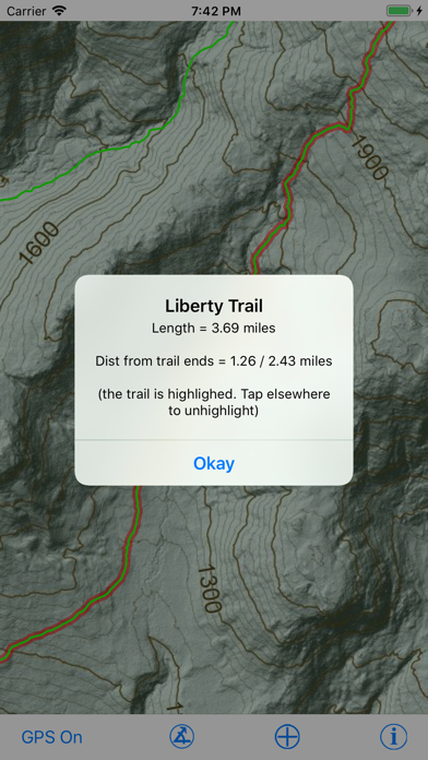
The Chocorua Map app is a mobile guide to trails and points of interest (POIs) in and around Mt. Chocorua and its eponymous Lake, especially the area preserved, directly or indirectly, by the Chocorua Lake Conservancy (CLC). If you allow the app to use your location (e.g., GPS), you can find and track your position on the map. The app contains abundant information on trails, including how long it should take at a given pace, as well as historical and geological points of interest.. Measure distances and compass bearings by tapping and dragging on the map. Publicly accessible lands of different types are shown with transparent color overlay. The background map was rendered from LiDAR topography and has a resolution of 1 meter.
The app's built-in POIs describe sites of historical interest, unique landscape features and how they developed, and features of geological and ecological significance. The user may enter their own POIs and attach photos to them; all user-entered information remains private to user's device. The user can share their POIs with other people or apps via the standard iOS Sharing Panel. The app is completely self-contained: No internet connection is necessary. Furthermore, user data is NEVER uploaded automatically to the Internet and can never be seen by the app programmer, CLC, or any other third party.
This app is for educational purposes only and should not be used as a sole source of navigation. The CLC and the author are not responsible for the accuracy of any of the information presented by this app.
Quoi de neuf dans la dernière version ?
v. 3.1.0 -- 2 December 2025
• NEW: Trails and roads are now labeled directly on the map at map zoom values greater than 14. No more tapping on a trail to find out its name! Of course you still can tap on a trail to get more information about it.
• FIXED: Some bugs in the previous release.
v. 3.0.0 -- 23 November 2025
The app has been complete rewritten using the same template as my White Mountain Hiker apps so it is way more capable than previous versions! Some of the new features include:
• Hiking timetable based on a user adjustable pace. The default is "book time" as used in the AMC White Mountain Guide, which is 2 MPH + 30 minutes for each 1000 feet of vertical gained. The timetable shows the interval distances and times to all trail intersections and/or trail segments.
• NWS weather forecasts for any point on the map so you can compare the weather on the top of Chocorua to that on the lake.
• New photos, updated trails, and expanded trail descriptions.
• Map legend enabling you to turn on or off trails, public land outlines, points of interest (POIs) by type, etc.
• Subtle shading indicating the extent of Chocorua lake Conservancy (CLC) covenanted (private) lands
• Get driving directions, rangefinder, make custom hikes, ephemeral sketches on map, etc.
• Add a photo POI right from the map screen
• The Settings Screen (gear icon) provides access to a comprehensive users manual, links to WMNF, HikeSafe, and CLC web pages, as well as many adjustments.