Fires: Wildfire Info and Atlas
iOS Universel / Navigation
Stay informed and safe with Fires, the trusted wildfire and prescribed burn tracking app. Fires features stunning, interactive maps powered by WhirlyGlobe—an advanced mapping engine used by air traffic controllers for its accuracy and reliability. Explore real-time fire locations, perimeters, and air quality data on a beautiful 3D globe. Whether you’re at home or on the go, Fires gives you the critical information you need, using the same technology trusted by aviation professionals.
Developed by a team with a proven track record in critical mapping solutions, Fires is built by the same experts who previously created situational awareness maps for the US Navy, used in post-conflict zones around the world. Our experience in delivering reliable, mission-critical geospatial technology ensures you get the most accurate and trustworthy wildfire information available.
▶ Nearest Wildfires and Fires
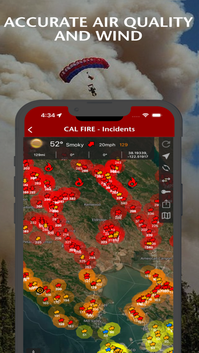
Fires provides a unified feed of the closest wildfires from supported agencies and NASA satellite hotspots, all at the top of the Home screen. Instantly view key details like address, zip code, county, neighborhood, acres burned, and percent contained—everything you need at a glance.
▶ Incident Details
Fires provides maps, photos, perimeters, and information about wildfires from the following sources for the United States:
• InciWeb
• CAL FIRE
• NIFC
See evacuation updates, view air tanker locations, share wildfire information and high resolution photos, .
▶ Alerts with Containment Updates
Fires will notify you when new incidents are downloaded within the maximum distance that you set from the source that you select including InciWeb and CAL FIRE.
▶ Thermal Hotspots and Fire Activity
Fires lets you to interactively browse the full set of global active fire detections from MODIS and VIIRS:
• Collection-6 MODIS Active Fire Data
• VIIRS I-Band 375m Active Fire Data
▶ Satellite Images and Animations
Fires provides extensive near real-time GOES (Geostationary Operational Environmental Satellite) imagery from NOAA.
▶ Global Weather Conditions including Wind and Air Quality (where available).
▶▶ ATLAS
▶ Offline 3D Basemaps, BLM maps, and USFS National Forest maps
• Several Basemaps
• Over 80 offline National Forest and BLM maps for California, Oregon, Washington, Alaska, Arizona, and Nevada.
▶ Mapping Tools with offline GPS functionality
▶▶ SUBSCRIPTIONS
Subscriptions automatically renew unless auto-renew is turned off at least 24 hours before the end of the current period. Your iTunes account will be charged for renewal within 24 hours of the end of the current period, and identify the cost of the renewal.
▶ FIRES PRO ELITE ($29.99/year)
Yearly access to the entire Fires Atlas, this includes unlimited access to all the Basemaps, BLM reference maps, and USFS reference maps.
• Access Incident Weather Conditions.
• Access Nearby Weather Conditions.
• Unlimited Global Weather Conditions using Waypoints.
▶ FIRES PRO ($14.99/year)
Yearly access to all the Basemaps along with yearly access to 4 BLM and USFS reference maps. Each reference map selection will last for 3 months at a time. After 3 months each reference map selection expires, then you can change that selection to any other reference map in the Fires Atlas.
• Access Incident Weather Conditions.
• 7 day free trial.
▶ TO MANAGE YOUR SUBSCRIPTION:
• TURN OFF auto-renewal via the main Settings app: http://support.apple.com/kb/ht4098
• Subscriptions automatically renew unless auto-renew is turned off at least 24 hours before the end of the current period. Your iTunes account will be charged for renewal within 24 hours of the end of the current period, and identify the cost of the renewal.
• Your iTunes Account will be charged at confirmation of purchase.
• Visit the following URL to view our Privacy Policy: http://www.livewaremedia.com/p/privacy-policy.html
• Visit the following URL for full terms of use: http://www.livewaremedia.com/p/terms-and-conditions.html
Quoi de neuf dans la dernière version ?
Added "NEARBY EVACUATIONS" button to Home screen. Press the button for quick access to real-time evacuation orders, warnings, and emergency closure information in your area. The feature connects directly to the Genasys Protect platform, providing location-specific evacuation data including evacuation zones, shelter locations, and emergency contact information. Users can view interactive maps showing evacuation boundaries, road closures, and safe routes. This feature is currently available for US locations and automatically centers on your current location for immediate access to local emergency information.