Singapore MRT Map Route(Pro)
iOS Universel / Navigation
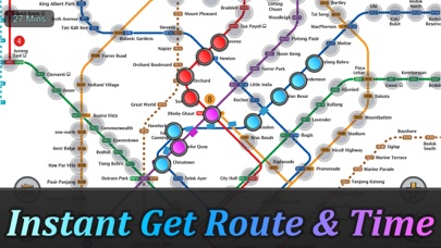
Singapore MRT Map Route est conçu pour permettre à l'utilisateur d'obtenir le meilleur itinéraire en une seconde.
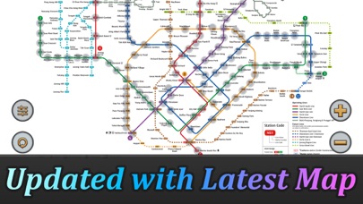
Voir la dernière carte du métro
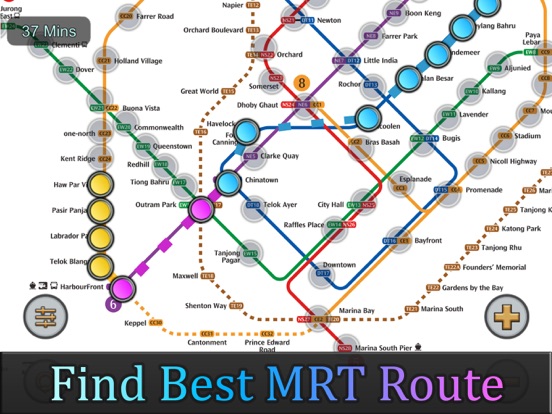
Calculer le meilleur itinéraire entre deux stations
Afficher le temps de trajet estimé
Mis à jour selon le dernier réseau de métro :
North-South Line (NSL)
Jurong East, Bukit Batok, Bukit Gombak, Choa Chu Kang, Yew Tee, Kranji, Marsiling, Woodlands, Admiralty, Sembawang, Canberra, Yishun, Khatib, Yio Chu Kang, Ang Mo Kio, Bishan, Braddell, Toa Payoh, Novena, Newton, Orchard, Somerset, Dhoby Ghaut, City Hall, Raffles Place, Marina Bay, Marina South Pier
East-West Line (EWL)
Tuas Link, Tuas West Road, Tuas Crescent, Gul Circle, Joo Koon, Pioneer, Boon Lay, Lakeside, Chinese Garden, Jurong East, Clementi, Dover, Buona Vista, Commonwealth, Queenstown, Redhill, Tiong Bahru, Outram Park, Tanjong Pagar, Raffles Place, City Hall, Bugis, Lavender, Kallang, Aljunied, Paya Lebar, Eunos, Kembangan, Bedok, Tanah Merah, Simei, Tampines, Pasir Ris
(Changi Airport Branch from Tanah Merah)
Expo, Changi Airport
North East Line (NEL)
HarbourFront, Outram Park, Chinatown, Clarke Quay, Dhoby Ghaut, Little India, Farrer Park, Boon Keng, Potong Pasir, Woodleigh, Serangoon, Kovan, Hougang, Buangkok, Sengkang, Punggol
Circle Line (CCL)
Dhoby Ghaut, Bras Basah, Esplanade, Promenade, Nicoll Highway, Stadium, Mountbatten, Dakota, Paya Lebar, MacPherson, Tai Seng, Bartley, Serangoon, Lorong Chuan, Bishan, Marymount, Caldecott, Botanic Gardens, Farrer Road, Holland Village, Buona Vista, one-north, Kent Ridge, Haw Par Villa, Pasir Panjang, Labrador Park, Telok Blangah, HarbourFront
(Marina Bay Branch from Promenade)
Bayfront, Marina Bay
Downtown Line (DTL)
Bukit Panjang, Cashew, Hillview, Beauty World, King Albert Park, Sixth Avenue, Tan Kah Kee, Botanic Gardens, Stevens, Newton, Little India, Rochor, Bugis, Promenade, Bayfront, Downtown, Telok Ayer, Chinatown, Fort Canning, Bencoolen, Jalan Besar, Bendemeer, Geylang Bahru, Mattar, MacPherson, Ubi, Kaki Bukit, Bedok North, Bedok Reservoir, Tampines West, Tampines, Tampines East, Upper Changi, Expo
Thomson-East Coast Line (TEL)
Woodlands North, Woodlands, Woodlands South, Springleaf, Lentor, Mayflower, Bright Hill, Upper Thomson, Caldecott, Stevens, Napier, Orchard Boulevard, Orchard, Great World, Havelock, Outram Park, Maxwell, Shenton Way, Marina Bay, Marina South, Gardens by the Bay
Quoi de neuf dans la dernière version ?
New v2.9.7