Toward
iOS Universel / Navigation
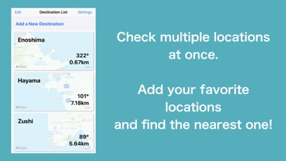
Navigation toward your destination!
This app will show you the distance to your destination and in which direction from your current location.
It can also be used in airplane mode, so it works on planes and ships.
There are no ads.
The UI is designed to be large enough to be used on the sea and easy to operate even your device is in a case.
The simple design makes it easy to recognize the information at a glance.
How to use:
1. Set your destination from the map or latitude and longitude! (For the example, the data of "Enoshima" is set.)
2. On the list page, you can see the locations that you have added so far. Let's find out where the closest one is to your current location!
3. Tap the destination on the list to start the navigation. (Please check the actual surroundings and follow the traffic rules strictly)
4. By tapping the Edit button, you can sort, delete, and re-edit the destination.
5. The setting page allows you to change various units.
Note:
- Since this application works with GPS, you cannot use this in tunnel or underground environments.
- Do not operate this application while driving, because it is dangerous.
- The straight line is not correct because the map is drawn by Mercator method. Please note that the more distant the destination, the greater the error will be.
- Application developer is not responsible for any disadvantages such as accidents and injuries while using this application. Please be sure to use this at your own risk.
Quoi de neuf dans la dernière version ?
Added the destination search function


