White Cloud Blue Sky
iPhone / Sports
Adds various aviation tools to your iPhone.
FLIGHT DATA
Uses your iPhone's sensors to display key data such as your direction/track, altitude, climb rate and ground speed.
Altitude includes AMSL (above mean sea level, calibrated using GPS), QNH (altitude calibrated using QNH pressure reported by a nearby airport) and user altitude (set by zeroing at a given place/elevation). The Metrics page provides a compact, single-screen overview; go to the various other pages for detailed information. The Altitude page also shows ground level and AGL altitude (if terrain data has been loaded for your location).
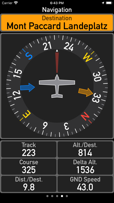
NAVIGATION
Use the navigation page to search for known points of interest in your area, such as airports, gliderports, heliports or paragliding/hanggliding sites.
Filter by type to find what is relevant to you. Tap on a point of interest to navigate towards that site.
For commercial airports, the app shows airport details such as ICAO/IATA code, traffic type (VFR/IFR), radio frequencies in use and runways (orientation and physical length).
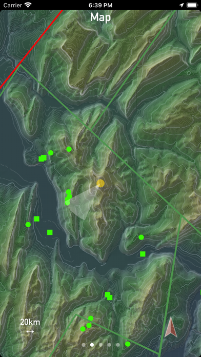
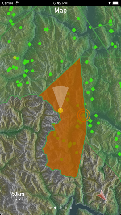
MAP
The map page supports the following layers (which can be individually enabled):
- Topography with hill-shading and color gradients for terrain. Map tiles are downloaded for offline use. Current coverage: Alps region. Other regions will be added over time.
- Airspaces.
- Places (points of interest).
Offline use -- works in remote locations and mountainous regions where mobile data might not be available.
AIRSPACE
The Airspace page displays airspaces surrounding your location with their class, floor and ceiling.
WEATHER
The METAR page displays weather information from airports around your location.
It automatically selects the source which is closest to your location (most relevant to you). Other sources can be selected manually using a list of available stations.
Weather info includes wind speed and direction, air and dew point temperature, air pressure and cloud conditions.
The QNH/pressure data reported is used to calibrate the watch's barometer, allowing the app to display your QNH-based altitude.
VARIOMETER
If enabled, the app plays tones with varying pitch, corresponding to your climb rate. This allows you to monitor your climb rate without constantly looking at the iPhone's display.
DATA SOURCES
Data sources currently supported:
- Worldwide airport and airspace data via openaip.net
- Weather data (METARs) via aviationweather.gov
- Worldwide free flight database via paraglidingearth.com
- European free flight database via DHV.de.
- Terrain (elevation) data via viewfinder panoramas.org. Current coverage: parts of Europe.
- Map tiles are available as part of the app (downloaded on demand from App Store).
Once you have downloaded points of interest, airspaces and terrain data, the app does not need internet access. All of its features work offline except for the METAR page which provides up-to-date weather reports on request.
Settings allow you to switch between physical units for distance (km or mi), altitude (m or ft), speed (km/h or mph), climb rate (m/s or ft/min) and temperature (deg C or deg F).
While this app runs on iPads, please note that due to the absence of a pressure sensor, some features will not be available (such as climb rate, QNH altitude).
Intended use: this app is neither a replacement nor an alternative to aviation-grade flight instruments and official aeronautical charts.
Quoi de neuf dans la dernière version ?
This version detects flight (airborne) state, which allows the app to automate some settings (e.g. start flight recorder). Metars can now be loaded automatically. Colors have been updated for more consistency across the user interface and higher contrast.